The Old 'Island Barn'
"Coastal Path“, as the trail is known, is ideal for those who do not want to face cliffs and gorges. Without major obstacles, it is made on flat stretches for almost the entire route, where the visitor passes through coves with calm waters and through seven villages (in order: Vila Verde, Praia Seca, Praia da Areia, Baixada, Centrinho, Praia do Sul and sachet). The highest point is after Ponta da Areia, from where an unforgettable view can be seen: a panoramic view of the dunes of Joaquina Beach, the Lagoon in all its extension, the Rio Vermelho Ecological Reserve, from Morro da Barra da Lagoa and Ponta da Galheta.
It covers about eight kilometers through a region that, since the middle of the 26th century, has been engaged in agricultural activities. There were once XNUMX sugar mills – today there are just a few, which end up becoming a tourist attraction. Cassava flour, coffee, sugar and brandy supplied the Vila de Nossa Senhora do Desterro (later Florianópolis) and the ships that anchored in its port for more than a century. THE Lagoon coast it was “island granary”.
The path ceased to be conserved in 1945. Until then, it was possible to travel its entire length by buggy or oxcart. The story of the place where a certain Manoel da Costa lived in the region, a wealthy landowner, who had the branches of trees that touched his hat as he passed by on horseback be cut. Another, a mill owner, rode with a slave on foot, taking part of the purchases made in the Parish of Lagoa.
A Walk through the Seven Villages
At the end of Estrada Geral do Canto dos Araçás, when the paving is over and you can only go on foot, the Caminho da Costa begins. A well-marked trail, between the Atlantic Forest and the Conceição Lagoon, passes through the seven villages. Throughout the region there are other paths that connect the east side of the island, but the main one should be kept.
Some villages have bars and restaurants, such as Bar do Seu Manoel, in the town known as Vila Verde, right at the beginning of the walk. But it is in Centrinho da Costa that the best-known restaurants are located, such as Coração de Mãe, mentioned in the Quatro Rodas guide.
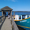
The Costa da Lagoa trail ends at Saquinho, but to return, take a boat from Praia do Sul. Disembarkation is at the Centrinho da Lagoa pier, after about an hour's journey across the lagoon. These vessels carry passengers daily, working as a bus service and the ticket costs R$ 7,50 (price can be changed in high season).
Details
Difficulty level: medium.
Attractions: lagoon, panoramic view, waterfall, river, beach, water source, Atlantic Forest, boat ride, restaurant.
Time: About 7,5 hrs in total, 4,5 hrs to go up and 3 to come down 4h
Home: End of the Estrada Geral do Canto dos Araçás.
End: Saquinho Beach.
Main difficulty: extensive.
How to get there: Continue straight ahead, after the end of Estrada Geral do Canto dos Araçás.
Where sleep in the eastern part of the island:
who can help: Companies of Tourist Services.
Beaches Guide: Learn more about the east island beaches.