
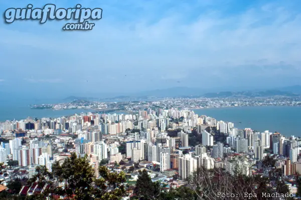
Florianópolis Center - Florianópolis Neighborhood


Região: Central Region of the Island
Close quarters: Jose Mendes (2,6 km) | Bag of Lemons (4,8 km) | agronomic (4,8 km) | Narrow (4 km) | Coconut trees (4,4 km)
Nearby beaches: Cacupe beach (13 km north) | Conceição Lagoon (16 km east) | soft beach (18,2 km east) | Joaquina Beach (19 km east) | Campeche beach (15,4 km south)
Distance: Airport 17 km
Also find: gastronomy, boat trips, colonial architecture, Night life, museums, churches

O Florianopolis downtown is the main and oldest district of Florianópolis, originally founded with the name of Village of Nossa Senhora do DesterroIn 1675.
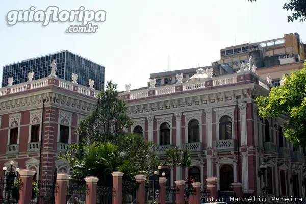
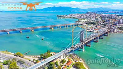
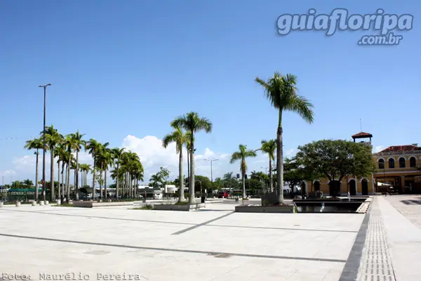
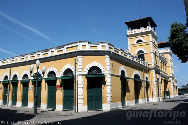
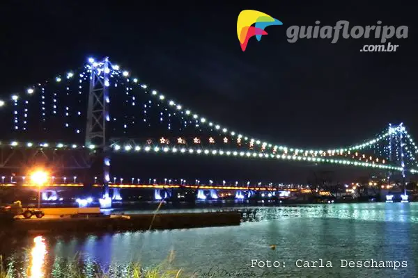
In the center is gathered the largest number of tourist attractions and historical and cultural attractions of the Island of Santa Catarina, such as the Hercílio Luz Bridge: Florianopolis Public Market, XV de Novembro Square with your Centenary fig tree: Largo da Antiga Alfândega and the entire Luso-Brazilian architectural ensemble of the XNUMXth and XNUMXth centuries present in the historic buildings.
The various museums in the center tell the political, artistic, cultural and military history of the city, such as the Santa Catarina Historical Museum - Cruz e Sousa Palace: Victor Meirelles Museum and the Major Antonio de Lara Ribas Arms Museum.
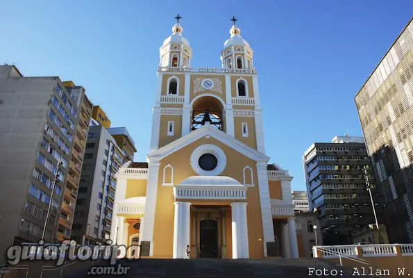
The various churches also tell the religious history of the capital, and draw attention for the collections of religious art and colonial architecture, highlighting the Metropolitan Cathedral and Chapel of the Child God.
The strong trade and the great diversity of center services ensure streets are always busy throughout the day, especially during the week. At night, the movement of residents and tourists is concentrated in a few places, such as Avenida Hercílio Luz, the North Seaside Avenue and Rua Bocaiúva, with its Bars and restaurants several.
Despite its name, the Center is located in the west of Santa Catarina Island, between Morro da Cruz and the sea, at the closest point to the mainland. The only three terrestrial entrances to the island are located in the center, which further increases the problem of urban mobility in this most populous area of the city.
History
Talking about downtown Florianópolis is often talking about history and the events that took place in the city's initial landmark.
The political heart of the capital and the state, the Center has already received extremely illustrious figures such as the Brazilian Emperor Dom Pedro II and his wife, the Empress Dona Teresa Cristina. It was also the stage for the Novembrada, a great popular demonstration that took place during the visit of the last president of the military regime, General John Baptist de Oliveira Figueiredo.
It was there that the bandeirante Francisco Dias Velho disembarked for the first time, founding the village of Our Lady of Desterro and requesting the construction of a chapel in the place where the Metropolitan Cathedral of Florianópolis.
Due to its strategic position between Rio de Janeiro and Buenos Aires, Nossa Senhora do Desterro did not take long to stand out in port activities. The relationships established with other regions made the flow of visitors grow and also allowed commerce to flourish around the port, in places such as Trapiche Miramar, the first Public Market and the customs.
In addition to the seafront, the growth of the Center was guided by the Igreja Matriz (Metropolitan Cathedral) and the paths that led to the water sources, close to the surrounding hills. Until the beginning of the XNUMXth century, there were four of these sources, the largest and most famous of which was that of Rio da Bulha. This river was born in Morro da Boa Vista, passed under the Ponte do Vinagre and emptied beside the Santa Barbara Fort.
ADVERTISING
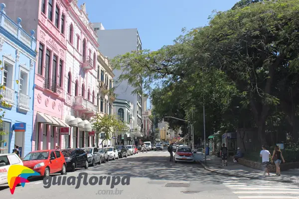
In the second half of the XNUMXth century, the small neighborhoods that made up the Center began to be differentiated from one another due to the social class of their inhabitants. east of current XV de Novembro Square, fishermen, washerwomen and prostitutes lived in small tenements. To the west, some of the wealthiest families in the city occupied beautiful townhouses.
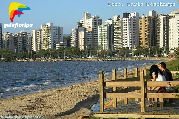
The first place on Santa Catarina Island to be used as a bathing station by the city's elite was Praia de Fora, which corresponds to the current North Seaside Avenue. At the end of the XNUMXth century, some families built their summer residences in the region, then considered far from the tumultuous life of the urban center. Having a house in Praia de Fora, at the time, was synonymous with social status.
It was also at the end of the 1884th century that the first proposals for backfilling the wetlands of the Center appeared. The main arguments defended were two: to take advantage of the space for the construction of buildings and to prevent the dumping of garbage in this type of land. Thus, in XNUMX, work began on the landfill at Praia da Bela Vista, which extended from Forte Santa Bárbara to the ascent of the Charity Hospital.
In 1896, the old Public Market was demolished after decades of operation and some trees were planted in its place. Only two years later, in 1898, did a new Florianopolis Public Market was opened. Although the location of the building is the same as we know it today, only part of it is the result of the original works.
Other large-scale landfills and works were carried out during the first years of the XNUMXth century, such as the canalization of rivers, the widening of the streets, the construction of squares and the implementation of a public lighting system with electricity. This desire for modernization eventually pushed the poorest strata of the population away from the Center, which led to the occupation of the Mocotó and Caixa hills.
ADVERTISING
However, the biggest and most important work to be carried out at the Center was yet to come. Conceived and executed by the governor who gives it its name, the Hercílio Luz Bridge it was an impressive piece of engineering and architecture for the time. Until its inauguration in 1926, the only way to reach Santa Catarina Island was to cross the canal by boat.
The downtown landscape continued to change through the 1960th century with the embankments of the North (1970s) and South (1975s) bays and the construction of the Colombo Salles (1991) and Pedro Ivo Campos (XNUMX) bridges. With the growth of population and traffic in the capital, new urban terminals were created (Integrated Transport System) and, recently, an elevated access road to Avenida Beira Mar Norte.
Video-photos of the Centro neighborhood
Accommodation in downtown Florianópolis
Consult hotels and other accommodation options in downtown Florianópolis partners of the Guia Floripa Portal.
DISCOVER MORE Neighborhoods in the Central Region from Florianopolis
- agronomic
- Centro
- Big Stream
- Itacorubi
- John Paul
- Jose Mendes
- Monte Verde
- Pantanal
- Bag of Lemons
- Big bag
- Santa Monica
- Trinity
- Bunker
