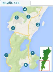
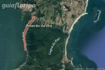
Ribeirão da Ilha - Florianópolis neighborhood


Região: south of the island
Close quarters: Tapera neighborhood (4,8 km) | Campeche neighborhood (10 km)
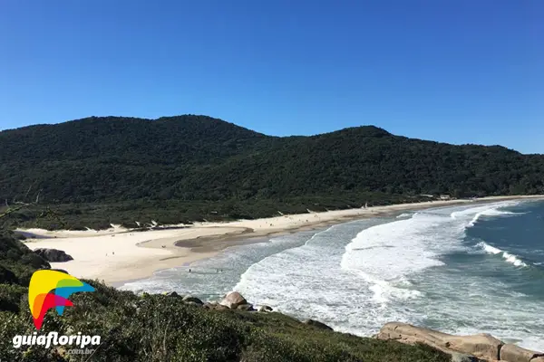
Nearby beaches: Ribeirao da Ilha beach | Tapera Beach (north)| Morro das Pedras beach (east)| Shipwrecked Beach (south trail)
Distances: Centro e Bus Station 22 km | Airport 10 km
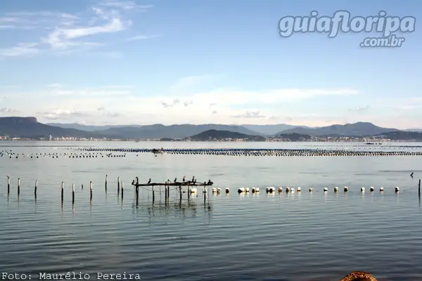
Also find: water sports, fishing, mariculture, colonial architecture, gastronomic route.

O Ribeirão da Ilha neighborhood is located in the southwest of Santa Catarina Island, 22,7 km from downtown florianopolis, between the neighborhoods Taper, Campeche e south swamp. Ribeirão da Ilha is also an administrative district of Florianópolis and its area covers about 51,54 km², extending from the Shipwrecked Beach, in the extreme south of the island, to the mouth of the Tavares River, on the border with the Coastal neighborhood of Pirajubaé.
Despite occupying a large part of the south of the island, the neighborhood itself is concentrated along the 21,8 km of the main road, Rodovia Baldicero Filomeno, which starts at Trevo do Erasmo, junction with Rodovia SC-405, and extends to the extreme south of the island, in the town of Caieira Barra do Sul.
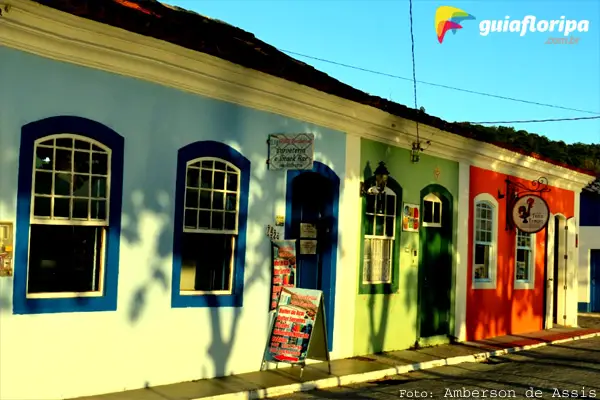
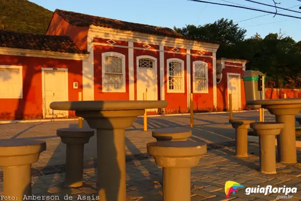
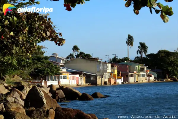
Because of the distance from the Center, Ribeirão da Ilha still maintains its simple and modest characteristics, with an air of interior and customs of Azorean origin. It is a dormitory district, which preserves the quality of life. There are no buildings and most of the residences, especially those close to the historic core, still retain the characteristics of colonial architecture.
Commerce in the neighborhood is limited to the essential needs of its residents, with markets, pharmacies, bakeries, construction material stores, among others. However, it is in the gastronomy that he stands out. Along the main road there are a large number of bars and seafood restaurants, where you can taste the main products produced in the region: oysters and shellfish.
ADVERTISING

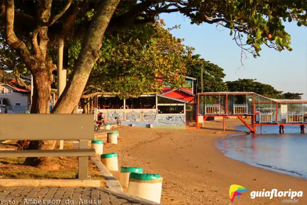
Life in Ribeirão da Ilha is peaceful and bucolic. Main leisure it is the sea, but there is a local club, Canto do Rio, where dances and small shows take place.
With an extensive coastline formed by small beaches, Ribeirão da Ilha is the right destination for those seeking peace and close contact with nature. At the southernmost point of the neighborhood departs one of the most famous trails Florianópolis, which connects the town of Caieira da Barra do Sul to Shipwrecked Beach.
For cachaça and adventure lovers, a good tip is to taste the "marvada" produced at Alambique do Zeca. But to get there, a good dose of courage is needed to face the road, which connects the town to the Pântano do Sul through the Sertão do Peri. Another good option - and with easier access - is to try Intizica, a cachaça sold by the Ostradamus restaurant.
History
The first European expeditions to dock on Santa Catarina Island chose Ribeirão da Ilha as their landing point because it is an area protected from stronger winds. The name given to the neighborhood came from a small river located in front of Ilha Dona Francisca, which the indigenous people - who had already inhabited the region for at least 2.000 years - gave the name of “ribeiracô”.
The first navigators arrived at Ribeirão da Ilha around 1506. Twenty years later, sebastião caboto, a Venetian navigator in the service of the Spanish crown, crossed the Atlantic Ocean and, according to reports, it was in the port of Ribeirão that he anchored. According to the expedition's chroniclers, Caboto considered the native population "docile", which is why he started the construction of a camp on land, having even erected a church.
Over almost two centuries, the locality practically disappeared from the chronicles and reports of travelers who passed through Santa Catarina Island. It was only in 1712 that Ribeirão da Ilha would be recorded again, this time in the writings and sketches of Amédée François Frézier, a French military engineer who carried out a study with the intention of drawing up a map of part of what would become the coast of Santa Catarina.
A few years later, between 1748 and 1756, the effective colonization of Santa Catarina Island took place with the disembarkation of about six thousand Azoreans and Madeirans. Some authors say that about fifty couples settled in Ribeirão da Ilha, where they started to produce food both for their subsistence and to guarantee the sustenance of the troops concentrated in the Fortaleza de Araçatuba.
ADVERTISING
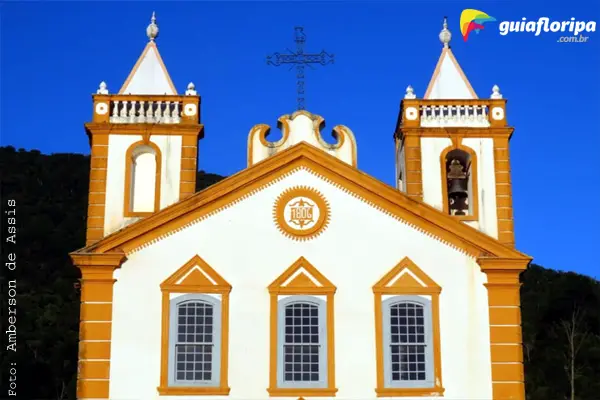
After the period of change and adaptation of the new residents to Ribeirão da Ilha, the Manuel de Valgas Rodrigues, who ordered the construction of a chapel to house an image of Nossa Senhora da Lapa. It is from this event that the parish would later receive the name of Our Lady of Lapa do Ribeirão. The chapel built by Valgas Rodrigues would be replaced by a church made of stone.
Over time, agriculture established itself as the main activity of the residents of Ribeirão da Ilha. They planted, among other things, manioc, corn, sugar cane, beans, coffee and flax. The coffee produced there was even considered one of the best in Brazil. Linen was used as raw material for making the nets used in artisanal fishing. Another prominent activity in the community was whaling.
The need to sell this production made the locality have three ports in full operation. These ports were also the main responsible for communication between the Ribeirão and the central village, since navigation used to be easier than access by land. In Santa Catarina Island, in particular, this dynamic would be maintained for many years due to the abundance of hills, mangroves, rivers and forests.
ADVERTISING
However, with the arrival of the XNUMXth century, this dynamic would undergo profound transformations. With the inauguration of Hercílio Luz Bridge, in 1926, land transport began to be valued at the expense of maritime transport, which eventually caused the decline not only of the existing ports in Ribeirão da Ilha, but also of its economic activities. This caused the region to enter a true period of stagnation.
It was only in the 1970s, with the modernization of the urban complex of Florianópolis, that Ribeirão da Ilha returned to the center of attention. The Baia Sul landfill facilitated access to the neighborhood, which attracted new visitors and residents. Consequently, most of the natives started to dedicate themselves to activities related to tourism. There was also an incentive, around the same time, for the cultivation of marine molluscs.
The relative isolation to which Ribeirão was subjected meant that many of the cultural characteristics of its inhabitants remained practically the same until today. Religious festivals such as Nossa Senhora do Divino Espírito Santo and Nossa Senhora da Lapa, the production of bobbin lace and also the presentations of Papaya Ox and Tape Stick.
Location of Ribeirão da Ilha:
DISCOVER MORE Neighborhoods in the South Region of Florianópolis